How do marine heat waves affect cold-water corals in the deep-sea?

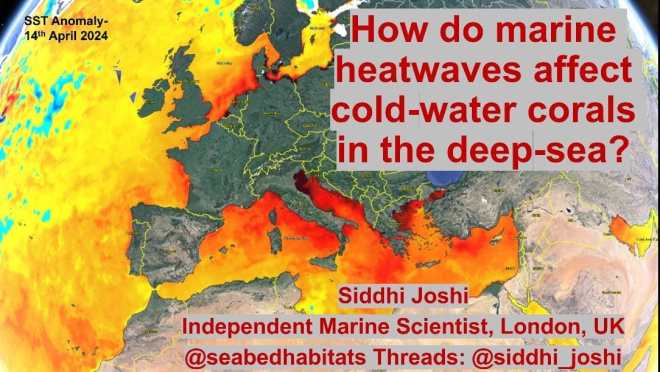
Ocean temperature plays an important role in governing the biophysical environment and in turn the realized ecological niche of benthic organisms and the distribution of marine habitats in the global ocean. As a result of anthropogenic-induced climate change Marine Heat Waves (MHWs) have resulted in widespread coral bleaching and mass mortality of tropical corals. Comparatively little is known about the impact of sub-surface MHWs on cold-water coral communities in the deep-sea, which lack the dependence on symbiotic zooxanthellae of their tropical cousins in surface waters. This study aims to address this deep-ocean knowledge gap utilising numerical modelling.  

Previous studies have shown that prolonged and intense sub-surface MHWs and their cumulative intensity results in increasing thermal stress encountered by benthic organisms in depths down to 2000m. This study utilises hydrodynamic modelling outputs of reanalysis data to study impacts of sub-surface MHWs on cold-water corals. With intensification and duration of sub-surface MHWs predicted to rapidly increase in this century, it will increase the thermal stress experienced by cold-water corals and associated communities in the deep-sea.

It is hypothesized that through increased stratification and increased mixed layer depth due to increased storminess and deepening of the thermocline, cold-water coral distribution will be impacted physically (mechanically), however their mortality is more likely to be dependent on food availability and oxygen supply. Preliminary results support this hypothesis in the North Atlantic, indicating that although the cold-water corals may be resilient to thermal stress physiologically, the resulting physically dynamic environment will lead to secondary impacts at the local scale in the benthic boundary layer. Furthermore, oxygen saturation has been found to decrease with increasing temperature and is likely to have a secondary impact on cold-water coral health. This study demonstrates how numerical modelling can provide quantitative spatial and temporal information of biophysical interactions to inform marine habitat mapping studies and species distribution models of habitat suitability. 

(Background: This is my research abstract made for the GeoHab 2024 conference – if you would like to learn more, my short oral presentation will be happening on Thursday 9th May 2024 at 1330 in Arendal, Norway. More information about the conference, including how to be a virtual participant, on the official conference website. An interesting program!) See also: https://www.marineheatwaves.org

Smritivan Earthquake Museum

The Smritivan Earthquake Museum and memorial are a testament to resilience and remembrance of the Kutch earthquake of 2001. Located in Bhuj in western part of Gujarat state in India, the epicenter of the earthquake was located at 23.36°N 70.34°E. This devastating earthquake had a tremendous impact on the region and claimed over 12 932 lives, with 167000 people injured.

The 2001 Earthquake was a catastrophic event for the people of Kutch, one that reshaped the landscape of the region in profound ways. Despite the massive setback, Gujarat, and its people, have demonstrated resilience in turning the adversities faced during this calamity into opportunities. Gujarat in quick span of time rebounded and grew ever stronger from the devastation.

Official website of Smriti van Earthquake Museum
Rediscover (section 2) video discusses the land habitats of Gujarat state (in Hindi with automated translated subtitles available on YouTube)

The Earthquake Museum is 11,500 Sq. mts and is divided into seven blocks named Rebirth, Rediscover, Restore, Rebuild, Rethink, Relive and Renew each representing a different aspect of what the museum stands for. From the earth’s evolution to Gujarat’s topography and its vulnerabilities to various natural occurrences and the aftermath of 2001 Kutch Earthquake. From Gujarat’s saga of rebuilding and success stories to finally paying digital homage to all the victims. All experienced through artifacts, images, art, and virtual stimulations, among others

Official website of Smriti van Earthquake Museum
360° Earthquake simulator was very realistic. It really brought home the feeling of experiencing an earthquake.

See also: https://www.smritivanearthquakemuseum.com

NASA Needs Your Help Classifying Coral Reefs – NeMO-Net

NeMO-Net is a single player iPad game where players help NASA classify coral reefs by painting 3D and 2D images of coral. Players can rate the classifications of other players and level up in the food chain as they explore and classify coral reefs and other shallow marine environments and creatures from locations all over the world!

http://nemonet.info/

International Coralline Algae Meeting 2023 happening in Sweden

Source: Official Website of conference

The 7th International Coralline Algae Meeting will take place in Umeå in Sweden this August 2023! The meeting will be followed by an Arctic field trip in Tromsø, Norway.

The meeting will have a multi-disciplinary flavour, welcoming submissions spanning the ecology, biogeochemistry, geology, evolution, physiology and conservation of free-living, crustose and geniculate coralline algae, with a forward-looking view to emerging frontiers in the field.

7th International Coralline Algae Meeting 2023

The full details of registration can be found at the official conference website. Its been a long wait following lockdown!!

Integrating sediment dynamics into habitat mapping approaches using sediment mobility indices and seabed classification in Galway Bay, Ireland.

Sediment dynamics information provide vital insights into the important role of oceanographic forcing factors on habitat distribution; yet remains an under-utilized physical surrogate in marine habitat mapping studies. An integrated oceanographic and geophysical analyses of dynamic processes combining sediment mobility indices, obtained from coupled-hydrodynamic- wave sediment transport models; with seabed classification has been made at Galway Bay, Ireland.

Maerl or rhodolith coralline red algae beds are abundant in Galway Bay and these beds represent more than 65% – 70% of the maerl habitats in Ireland (De Grave and Whitaker, 1999). Maerl beds are particularly affected by hydrodynamics and increased storminess resulting in recurrent disturbance of the benthic habitat patch during winter storms. Live maerl beds are biodiversity rich coastal habitats and form subtidal and intertidal banks and open marine beds. Dead maerl beds of the branched maerl morphotype are considered to be biogenic sediment with form dense biogenic gravel debris beaches.

Sediment mobility modelling is of importance to a range of disciplines including sediment dynamics, marine conservation, coastal engineering, and renewable energy (Harris and Coleman, 1998; Idier et al., 2010; Li et al., 2015, Joshi et al, 2017a, Coughlan et al. 2021). It is based on the fundamental quantity of bed shear stress and the impact of pure currents, wave-only, wave-induced currents or combined wave-current flow on surficial sediments.

Multibeam backscatter from the INFOMAR national seabed mapping program of Ireland have been utilized for seabed classification using the new machine learning and deep learning libraries in ArcGIS Pro and Python.

An integrated interpretation of the dynamic processes happening at the seafloor is made as a result of the combined wave-current induced disturbance regime during storm conditions. Implications for future conservation management of maerl beds impacted by increased storminess and anthropogenic activity are discussed.

References

Coughlan, M., Guerrini, M., Creane, S., O’Shea, M., Ward, S.L., Van Landeghem, K.J.J., Murphy, J., Doherty, P., 2021. A new seabed mobility index for the Irish Sea: Modelling seabed shear stress and classifying sediment mobilisation to help predict erosion, deposition, and sediment distribution. Continental Shelf Research 229, 104574.

De Grave, S., Whitaker, A., 1999. A census of maerl beds in Irish waters. Aquatic Conservation: Marine and Freshwater Ecosystems 9,303-311.

Harris, P.T., Coleman, R., 1998. Estimating global shelf sediment mobility due to swell waves. Marine Geology 150, 171177.

Idier, D., Romieu, E., Pedreros, R., Oliveros, C., 2010. A simple method to analyse non-cohesive sediment mobility in coastal environment. Continental. Shelf Research. 30, 365–377.

Joshi, S., Duffy, G.P., Brown, C., 2017a. Mobility of maerl-siliciclastic mixtures: Impact of waves, currents and storm events. Estuarine, Coastal and Shelf Science 189, 173–188.

Li, M.Z., Hannah, C.G., Perrie, W.A., Tang, C.C.L., Prescott, R.H., Greenberg, D.A., 2015. Modelling seabed shear stress, sediment mobility, and sediment transport in the Bay of Fundy. Canadian Journal of Earth Science. 52, 757–775.

Cite as:

Joshi, Siddhi. (2022). Integrating sediment dynamics into habitat mapping approaches using sediment mobility indices and seabed classification in Galway Bay, Ireland. GeoHab 2022, Venice. https://lnkd.in/e9vHBu8v

StoryMap:

A StoryMap of this research can be found at the link